I have spent the last 4 years struggling with pesky satellites and the forests they are trying to measure. There are a number of approaches to mapping forests, with the most common approaches combining some kind of on-the-ground forest measurements with data from satellites. The way you measure forests on the ground is roughly the same; you decide on sampling strategy, set up you plot, and measure how wide and how high every tree in that plot is. Then you enter that data onto a computer, and use a particular equation to work out how much biomass is in the tree and the plot you inventoried. This data is then used to help interpret satellite data, so that similar areas of forest can be identified over a much larger area. There a variety of different satellites, and products derived from satellites that can be used for mapping forests, and they are all analysed in slightly different ways.
There are certain methodologies that, like a Marks and Spencer’s suit, may fit a large proportion of the population, but not perfectly. There will be odd angles and sleeves too long or too short, but on average, with a few clever accessories it will work just fine.
However there are some cases where the suit just can’t be made to sit right. Maybe we try another brand, another shop, in the hopes of finding something to fit. Maybe it works, or maybe it doesn’t. It might be that we get closer, but not quite perfect. Maybe this particular suit represents the best trade-off in terms of time we’ve spent shopping, cost and fit, so we put up with the limitations and accept what we have. Or we may be willing to pay more money to get closer to our ideal, maybe taking the suit to a tailor for some alterations. Or, rarely, we may decide that we want the best fit, so we are willing to wait and pay for some bespoke tailoring.
This analogy is pretty close to the choices and challenges faced when monitoring forests. Through my research in Malawi, I have tried a number of different approaches to work out how much forest is in Malawi, and how fast it is being lost. These are all approaches that have been tried in other areas, and used successfully, but for one reason or another don’t work quite as well as expected in Malawi. Globally applicable solutions may not work everywhere, without some additional country-specific data.
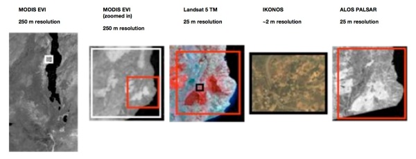
With different satellite data products, there are trade-offs between accuracy, processing time and cost. For example, there are some really useful, free global datasets, such as MODIS (MODerate Imaging Spectrometer), which is an optical sensor operated by NASA, with data distributed by the USGS. MODIS imagery has a coarse spatial resolution of 250 m to 1 km depending on the particular product used, but covers the whole globe every 8 days. It is usually quick to process, and is free to download. The opposite side of this are sensors such as Quickbird or IKONOS, which have very fine spatial resolutions (up to < 1 m), but cover such small areas at at time that they tend to be pointed over an area at the request of a particular user, so repeat data is more difficult to get. It is also expensive. There are numerous other satellite sensors that fit between these examples.
From my work in Malawi, it appears that there may be places where the costs of this bespoke approach are justified, as the errors from the standard, off-the-rack approaches are significant enough to make them difficult to hide with the right shoes or tie.

